

For many Filipinos, prolonged hot weather means running electric fans and air conditioners more often, which can lead to higher monthly electricity bills. When El Niño affects the Philippines, these challenges may become more noticeable as hotter and drier conditions increase the demand for cooling and put pressure on water supplies.
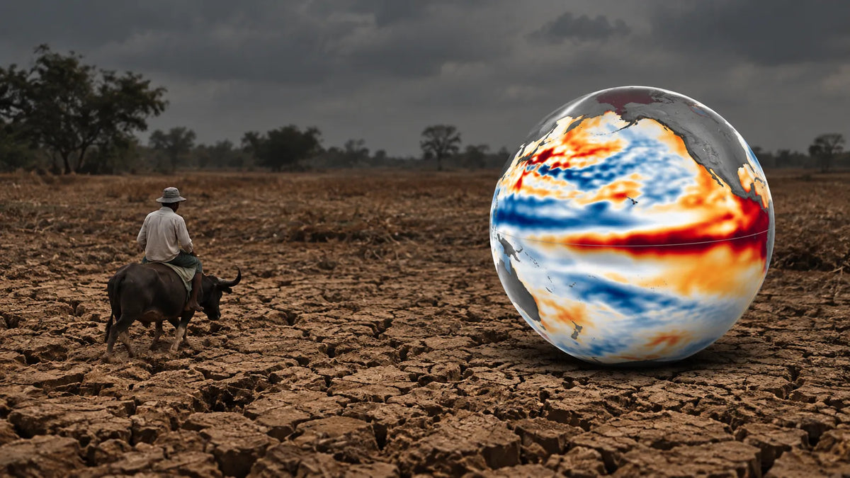
El Niño is a climate pattern characterized by warmer-than-usual sea-surface temperatures in the central and eastern equatorial Pacific Ocean. It can influence rainfall and temperature patterns, increasing the likelihood of below-normal rainfall, dry spells, and water shortages in parts of the Philippines.
As of October 9, 2026, PAGASA reports that a strong El Niño is active and may intensify to very strong, potentially lasting through the first half of 2027. This guide explores its expected effects on Philippine communities, agriculture, water supply, heat, and electricity consumption, along with practical ways to prepare.
|
Table of Contents |
|---|
What is El Niño?
El Niño is the warm phase of the El Niño–Southern Oscillation (ENSO), a recurring pattern involving the tropical Pacific Ocean and atmosphere. During El Niño, central and eastern equatorial Pacific waters become unusually warm, trade winds and atmospheric circulation change, and rainfall patterns shift in many parts of the world. La Niña is the cool phase; neutral conditions are neither phase.

The key phrase is rainfall patterns shift. El Niño is not a storm, a heatwave, or a forecast for identical weather in every province. It changes the odds of seasonal conditions; local weather systems still determine what happens on a particular day.
What does “very strong” or “super El Niño” mean?
Scientists measure the event using sea-surface temperatures in defined areas of the equatorial Pacific, alongside atmospheric signals. NOAA’s October 8, 2026 discussion reported a Niño 3.4 index of +2.1°C and anomalies above +4.0°C in parts of the eastern equatorial Pacific. Those are readings for specified regions—not a temperature increase across the entire Pacific or the Philippines. NOAA said the chance of a historic event, defined in its outlook as a three-month Relative Oceanic Niño Index (RONI) value of at least +2.5°C, was 83% for October–December 2026.

PAGASA describes the current event as strong and forecasts possible intensification to very strong. “Super El Niño” is a popular headline phrase, not a separate local warning category in the PAGASA advisory. For decisions in the Philippines, follow PAGASA’s current alert, seasonal outlooks, and local advisories rather than treating “super” as a promise of a particular impact.
El Niño-Affected Areas: Higher Temperatures and Heat Risk
PAGASA’s October 2026 agroclimatic outlook expects below-normal to near-normal rainfall across the country during October, with warmer to slightly warmer mean temperatures in most areas. PAGASA also notes that tropical cyclones and other rain-bearing systems may still bring above-normal rainfall, even during El Niño. The monthly outlook is a snapshot for October—not a province-by-province forecast for all of 2027.
The broader PAGASA advisory says El Niño generally raises the likelihood of below-normal rainfall and can increase the risk of dry spells, drought, and water stress in some areas. It also cautions that short-term heavy rain can still occur, particularly when monsoon conditions or tropical cyclones bring rain. In other words: a drier seasonal outlook and a rainy or flood-prone day can both be true.
Which areas are seeing higher temperatures or heat risk?
PAGASA’s recent reports show warmer-than-usual conditions in several places, but a temperature outlook is not the same as an official heat-wave warning. Here is the simple area-by-area picture:

|
Area |
PAGASA’s latest report or forecast |
Simple takeaway |
|---|---|---|
|
Most of Luzon (except Bicol), Negros Island Region, and western Mindanao |
Slightly warmer to warmer than usual in the October 8–14 forecast. |
These areas have the clearest near-term warmer-than-usual signal. |
|
Dipolog and Misamis Oriental |
Way above-average mean temperatures were observed in September 2026. |
These locations stood out as the strongest warm anomalies in PAGASA’s latest monthly review. |
|
Most other areas |
Slightly above- to above-average temperatures were observed across most of the country in September; warmer to slightly warmer conditions are expected in most areas in October. |
A broad warm signal does not mean every place will experience a heat wave. |
|
Northern Palawan, Occidental Mindoro, Romblon, and Bohol |
PAGASA expects cooler to slightly cooler-than-average conditions in October. |
These are relative cooler exceptions in the monthly forecast—not a guarantee of cool weather every day. |
|
Borongan, Eastern Samar |
Recorded September’s highest station temperature in PAGASA’s review: 37.7°C on September 3. |
A single-day maximum is not proof of a prolonged heat wave. |
Important: Heat index reflects how hot conditions feel when air temperature and humidity combine. For today’s local heat risk, check PAGASA’s daily heat-index updates; this table summarizes monthly observations and forecasts, not a live warning.
What this forecast does not mean: every part of the Philippines will experience drought; every day will be hotter than average; there will be no typhoons or heavy rain; or food prices and power bills will rise by a specific amount. Those outcomes depend on local rainfall, water storage, crop calendars, infrastructure, market conditions, and later weather.
A useful way to read the risk: place, timing, and buffer
Instead of asking only “How strong is El Niño?”, ask three practical questions:
|
Question |
Why it matters in the Philippines |
What to check |
|---|---|---|
|
Where is the rainfall deficit? |
National averages can hide large differences among islands, watersheds, and municipalities. |
PAGASA regional outlooks, local rainfall and drought advisories, and LGU water updates. |
|
When does the shortfall happen? |
The same rainfall deficit can have different consequences depending on whether crops are being planted, flowering, or maturing. |
Farm calendars, irrigation schedules, and the timing of local dry spells. |
|
What buffer is available? |
Stored water, functioning irrigation, household storage, savings, and access to alternate supplies affect how quickly a dry spell causes harm. |
Reservoir and utility notices, water-system reliability, and household or farm contingency plans. |
This “place–timing–buffer” lens is useful because climate signals are broad, while impacts are local. It also explains why preparation is valuable before a drought is formally declared: water demand and crop stress can build while the seasonal pattern is still unfolding.
What are the effects of El Niño in the Philippines?
1. Less dependable rainfall and dry spells
Below-normal seasonal rain can leave some communities with longer gaps between rain events. But El Niño does not switch off the Southwest Monsoon, tropical cyclones, thunderstorms, or other rain-bearing systems. PAGASA explicitly warns that localized heavy rainfall can occur alongside the wider dry signal. Keep drought readiness and flood readiness in the same plan.
2. Water supply and irrigation pressure When rainfall deficits persist, watersheds, reservoirs, and local water sources may receive less recharge. Households may face tighter supply, while farms that depend on irrigation or rain-fed production may need to manage water more carefully. Actual restrictions or shortages are local decisions and should be confirmed with the relevant water district, irrigation authority, or local government—not inferred from the El Niño label alone.
3. Heat stress and health precautions PAGASA’s current October outlook expects warmer to slightly warmer mean temperatures across most of the country. Heat exposure can be more difficult when humidity is high, shade is limited, or access to drinking water is unreliable. Plan strenuous outdoor work for cooler hours when possible, take water and shade breaks, and follow local heat and health advisories. The seasonal outlook does not mean every location will break a temperature record.
4. Farm decisions and possible food-price effects
Rainfall timing can affect land preparation, planting, flowering, and harvest differently across crops and regions. A missed or delayed rain can matter more at a sensitive growth stage than the same deficit at another time. PAGASA advises farmers to conserve water, maintain irrigation systems, consider drought-tolerant crops and soil-moisture conservation, and adjust activities using updated local forecasts.
Lower local production can contribute to price pressure, but El Niño alone does not determine retail prices. Imports, inventories, transport, fuel and fertilizer costs, trade policies, and market behavior also matter. Treat claims about a specific national price increase or global harvest loss as a separate, sourced claim—not an automatic consequence of the forecast.
5. Energy and household costs PAGASA identifies energy production among the sectors that may be affected by water stress. The scale and timing depend on the power system and local conditions; the forecast alone does not establish that brownouts or a set bill increase will happen.
For a household considering a solar panel for home use, solar energy may help generate electricity for on-site consumption, but it is not a drought solution and does not automatically provide backup power at night or during a grid outage. Ask an accredited, qualified installer about system design, safety, battery storage if backup is needed, and requirements from your distribution utility. The Department of Energy announced simplified rules in August 2026 for specified own-use solar systems, while retaining technical and safety requirements; confirm which current rules apply to your installation.
El Niño effect: Why the hardest impact may come later
Weather changes and human impacts do not always peak at the same time. A rain shortfall can first reduce soil moisture or disrupt planting; later, a household may feel the effects through lower harvests, reduced farm income, or the need to buy more food. The sequence and delay vary by place, crop, water access, and household resources. This is a practical reason to act on early warnings rather than waiting for visible losses.

There is no single “Philippines lean-season” date that fits every crop and province. Use local crop calendars and agricultural advisories. For example, one area may have a critical planting window while another is harvesting. National-scale statements about food insecurity or months-long recovery should not be copied from studies of other regions without clearly explaining that they are not Philippines-specific evidence.
What is the difference between El Niño and La Niña?
|
Feature |
El Niño |
La Niña |
|---|---|---|
|
Pacific signal |
Unusually warm central and eastern equatorial Pacific waters |
Unusually cool central and eastern equatorial Pacific waters |
|
Typical Philippine risk signal |
Higher likelihood of below-normal rainfall and dry spells in some areas |
Often raises the likelihood of above-normal rainfall in some areas |
|
What it does not guarantee |
Drought everywhere or an end to heavy rain |
Flooding everywhere or rain every day |
|
What to monitor |
PAGASA ENSO updates, rainfall outlooks, drought and water advisories |
PAGASA ENSO updates, rainfall outlooks, flood and landslide advisories |
El Niño and La Niña are opposite phases of ENSO, but their local impacts are not simple mirror images. Geography, season, monsoon activity, and tropical cyclones all shape the result. Even during El Niño, a tropical cyclone can bring intense rain; during La Niña, not every place will flood.
How to prepare for El Niño in the Philippines
For households
- Follow local advisories. Check PAGASA forecasts and your LGU or water provider for area-specific updates; do not rely on a national headline alone.
- Use water deliberately. Fix leaks, avoid unnecessary use, and store water safely where appropriate. Follow utility guidance and do not compromise sanitation or drinking-water safety.
- Plan for heat. Keep drinking water accessible, identify cooler places, check on children, older adults, outdoor workers, and people with health conditions, and follow public-health advice.
- Keep a two-sided emergency plan. A dry outlook does not remove the risk of a sudden thunderstorm, tropical cyclone, flash flood, or landslide. Keep drainage clear and know local evacuation guidance.
- Review power needs realistically. Reduce avoidable electricity use. If considering solar, compare the system’s daytime generation, battery and backup capability, safety, installer credentials, and applicable utility rules; a standard grid-connected solar panel is not automatically an outage backup.
For farmers and agricultural communities
- Maintain and clean irrigation canals, pumps, and water-storage facilities before they are urgently needed.
- Conserve water and consider rainwater harvesting where safe, lawful, and suitable for the site.
- Use local crop and soil conditions to guide planting dates, crop choice, and irrigation priorities; ask agricultural extension staff about drought-tolerant varieties suited to the area.
- Protect soil moisture with locally appropriate soil-covering or mulching practices, and monitor crops for moisture stress, pests, and disease.
- Harvest mature crops on time and dry and store produce properly. Continue monitoring forecasts because heavy rain may still occur during an El Niño period.
These steps reflect PAGASA’s current agricultural guidance, which includes conserving water, maintaining irrigation, using drought-tolerant crops and soil-moisture practices, and adjusting farm work to updated advisories.
For local planners and businesses
Map water-dependent communities, farms, and services against local rainfall outlooks; identify backup water and communication arrangements; and make trigger-based plans for conservation, public messaging, and support to affected households. Use PAGASA’s localized climate information and municipal-level tools where available rather than assuming national averages describe every locality.
Recommended EcoFlow Products for Every Household
Preparing for El Niño doesn’t require an expensive home energy system. Pick a power station based on your electricity needs, your budget, and the appliances you want to keep running during an outage.
|
Budget-Conscious Households |
|
|---|---|
|
Best for |
Essential backup power |
|
Can power |
Smartphones, laptops, LED lights, communication devices |
|
Recommended |
EcoFlow RIVER 2, RIVER 3 (UPS) |
|
Middle-Income Households |
|
|---|---|
|
Best for |
Everyday essentials |
|
Can power |
Multiple essential devices and selected low-power appliances |
|
Recommended |
EcoFlow RIVER 2 Pro, RIVER 3 Max Plus, DELTA 3 1000 Air |
|
Upper-Middle-Income Households |
|
|---|---|
|
Best for |
More comprehensive backup with longer runtime |
|
Can power |
Multiple household essentials, depending on appliance requirements |
|
Recommended |
EcoFlow DELTA 3, DELTA 3 Plus, DELTA 3 (1500) |
|
High-Income Households |
|
|---|---|
|
Best for |
Advanced home energy setups |
|
Can power |
Larger household energy needs, when properly designed |
|
Recommended |
EcoFlow DELTA Pro, DELTA Pro 3, plus compatible expansion batteries and solar panels |
How to choose
Before buying, check three things:
- Appliance wattage: how much power each device uses.
- Starting power: some appliances need extra power to turn on.
- Runtime: how many hours you need them to run.
A bigger battery means longer runtime, and higher output means more appliances. Solar panels add a way to recharge during the day, which helps during prolonged outages.
The bottom line
The most useful way to understand El Niño in the Philippines is as a changing risk signal—not a script for every province. The current 2026–2027 forecast points to a powerful event and heightened concern about rainfall deficits, heat, water, agriculture, and energy. But localized rain can still be heavy, and the actual impact depends on when and where the shortfall occurs and what buffers are available.
Prepare early, keep both drought and heavy-rain plans active, and revisit official forecasts as they change. For practical decisions, PAGASA’s current local advisories matter more than the label “super.”
Editorial note: This article is dated October 9, 2026. ENSO outlooks and local rainfall forecasts change; re-check PAGASA and NOAA updates before acting. Global crop-production, trade-policy, shipping-disruption, and macroeconomic figures are not included here because they require separate verification and should not be presented as Philippines-specific impacts without direct evidence.

Share: